MIRACLE data analysis tools
3) 1D-field
separation of the X component of a north-south IMAGE magnetometer chain
into its internal and external parts:
- Short description of the analysis
method:
The X component data of a 1D north-south
chain is separated into the parts caused by internal (i.e., flowing below
the ground, mainly geomagnetically induced currents) and external (i.e.,
flowing above the ground, mainly ionospheric currents).
Two different algorithms have been
developed:
-
Method working in Fourier space (algorithm
developed by Olaf Amm)
-
Method using a spatial integral transform (algorithm developed
by Ari Viljanen)
Both methods can be carried out for
a whole range of time quickly.
- Input data requirements:
IMAGE magnetometer data of the chain
NUR-NAL (X and Z components; see MIRACLE
map for stations overview).
- Output quantities:
Internal and external parts of the X component on the ground.
(Fourier method: Equally spaced on a north-south profile; Spatial integral
transform method: On the original magnetic data points)
- Literature:
-
Untiedt, J., and Baumjohann, W., Studies
of polar current systems using the IMS Scandinavian Magnetometer Array,
Space
Sci. Rev., 63, 245, 1993.
- Example plots:
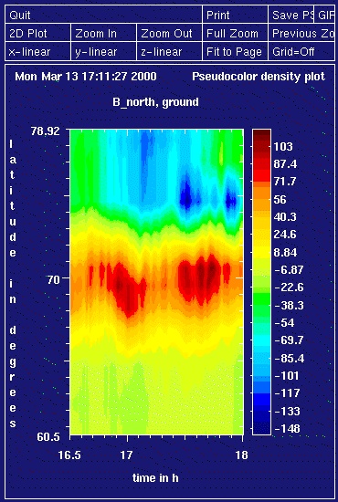
This is the input
data: measured X components of MIRACLE magnetometers
on January 17, 1998, between 1630 UT and 1800 UT, for the approximately
north-south aligned chain of stations reaching from NUR to NAL (see MIRACLE
map). The colour bar indicates the value of the X component in nT for
the respective times and latitudes.
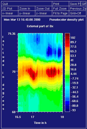
The plot below shows the
separated external part of the X component (on the ground) during
the same interval as for the input data. Note that the general structure
of the external part is similar to that of the total measured field (see
input). For this example, the Fourier space method was used.
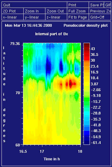
The separated internal part of the
X component (on the ground). This part is
usually somewhat smaller than the external part, and shows less structure.
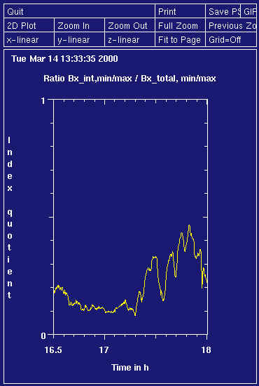
Finally, below is the ratio
between the minimum/ maximum of the internal part and the same value of
the total X component. This quantity describes
how much of a "chain AL or AU index" would be caused by the internal part
of the currents. Note that the value increases clearly after 1730 UT when
the westward electrojet intensifies at about 75 degrees of latitude (over
the ice sea). After that time, the ratio values come mostly from this westjet,
before they come from the eastjet over the land flowing at about 70 degrees
latitude. The westjet over the sea seems to cause relatively larger internal
currents, probably due to high sea water conductance.
For further questions contact Olaf
Amm (regarding the Fourier space method), or
Ari
Viljanen (regarding the spatial integral transform method).
Maintained by: Olaf
Amm
Latest update: 14. 2. 2000