
Map projection
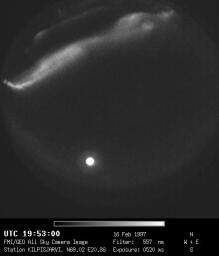
The fish-eye lens of the new all-sky imagers uses equidistant projection to image the half-space onto the image plane. This means that the angle between an incoming light ray and the optical axis and displacement of the image point in the CCD cell are linearly dependent.
In practice this means that the image is circular (the maximum incoming angle is 90 degrees). The horizon is imaged furthest away from the centre of the circle, and the zenith (ie. straight up) is in the centre of the image.
Now, take a look at the image to the left: there is an auroral arc to the north of the station and the bright spot in south is the Moon. If we map the image to an altitude of 110km we can see results in the image to the right. The green diamonds are placed in Kilpisjärvi, Muonio, Abisko and Kiruna.
 |
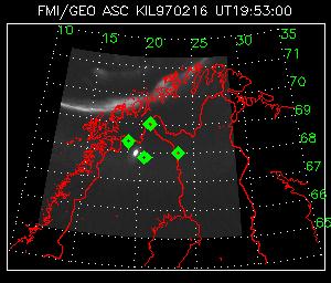 |
Please note that by using images from only one station, one can calculate only the direction (the elevation and the azimuth from the station). For these maps one assumes a fixed altitude -- clearly the Moon is not somewhere between Abisko and Kiruna at an altitude of 110km. To find the correct altitude stereo-imaging has to be used.
How the auroras move over Scandinavia
Here is an MPEG-animation (1.7MB) which demonstrates movements of auroras.
More information: Kirsti Kauristie
e-mail: firstname.lastname@fmi.fi