A new Nature Communications review article, led by Dr. Eduardo Maeda, shows how terrestrial laser scanning is transforming forest science. At the Earth Observation Unit of the Finnish Meteorological Institute (FMI), laser scanning and other geospatial technologies are applied from boreal forests in Finland to the tropics of Amazonia and Southeast Asia. Together with AI and satellite observations, they provide unprecedented insights into how human activity shapes ecosystems, and how we can manage forests more sustainably. Access the article: Nature Communications
Terrestrial laser scanning enables researchers to scan trees and forests in ultra-detailed 3D – not just from above, but from within. This new perspective is opening opportunities to:
- Track how trees grow and allocate resources
- Study how forests recover from disturbance
- Understand how structural complexity supports biodiversity and resilience
Through the FAME Flagship collaboration, funded by the Research Council of Finland, we work closely with Tampere University, the University of Helsinki, Aalto University, and the University of Oulu to advance forest-related AI, modelling, and Earth observation.
Smart Tech for a Living Planet
Human development has often been associated with deforestation, ecosystem disturbances, and climate change. But sometimes, technological advances can become part of the solution.
At the FMI Earth Observation Unit, researchers are using cutting-edge geospatial technologies to understand and mitigate human impacts on the world’s terrestrial ecosystems. Over the past decade, the unit has grown into a leader in the application of satellite imagery, drones, terrestrial laser scanning (TLS), and artificial intelligence to tackle the planet’s most pressing ecological challenges. This leadership has been further strengthened through a close research partnership with the University of Helsinki, which included the co-hiring of leading researchers in the field.
Shooting lasers in the forest
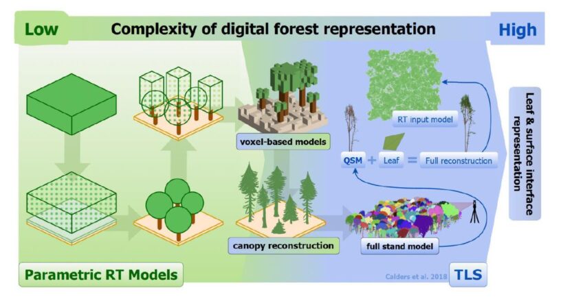
The success of this partnership is reflected in a major new publication released today in Nature Communications. The review article, led by Dr. Eduardo Maeda — Associate Professor of Remote Sensing of Environment at FMI since 2022 — and co-authored with prominent researchers from Europe, Asia, and the Americas, explores how terrestrial laser scanning (TLS) is transforming forest science. TLS enables researchers to scan trees and forests in high-resolution 3D, opening new avenues to quantify structure, track changes over time, and simulate ecosystem processes with unprecedented realism. “TLS is giving us a new lens to look at forests — not just from above, but from within,” says Maeda. “It’s helping us understand how trees grow, how forests respond to disturbance, and how structural complexity influences biodiversity and resilience.”
From Forests in Finland to the Tropics
At the Earth Observation Unit, this technology is being applied across continents and ecosystems. In tropical regions such as Southeast Asia and the Amazon, the team has used laser scanning and machine learning to assess the impacts of logging and forest fragmentation, uncovering subtle but lasting structural changes that affect carbon storage, biodiversity, and forest microclimates. In boreal forests like those in Finland, their research has explored how forest management influences tree architecture and growth, generating insights that support more sustainable practices and enhance national forest monitoring systems.
Altogether, the work from FMI’s researchers demonstrates that technologies like laser scanning, satellite sensing, and AI are reshaping the kinds of questions scientists can ask. By measuring ecosystems in fine detail and over time, these tools are revealing patterns and processes that were previously invisible, from how trees allocate resources to how forests recover from disturbance. This deeper understanding is helping researchers, policymakers, and communities make more informed decisions — and ultimately, to better align human activity with the long-term health of our planet’s ecosystems.
More information
Eduardo Maeda, Associate Professor, University of Helsinki and Finnish Meteorological Institute, eduardo.maeda@helsinki.fi
Review article is available on Nature Communications (2025)16:8853.
Reference: Maeda, E.E., Brede, B., Calders, K. et al. Expanding forest research with terrestrial LiDAR technology. Nat Commun 16, 8853 (2025). https://doi.org/10.1038/s41467-025-63946-6