
Satellite images can be utilized for near real-time mapping of floods in wide areas cost efficiently. New research shows that Finnish Flood Centre’s Flood Detection Algorithm works better in the Finnish environment when compared with other available satellite-based products.
Methods for satellite-based flood detection have been developed in the Finnish Meteorological Institute for almost 10 years. The Finnish Flood Centre, a service jointly run by the Finnish Environment Institute and the Finnish Meteorological institute, provides satellite-based flood maps.
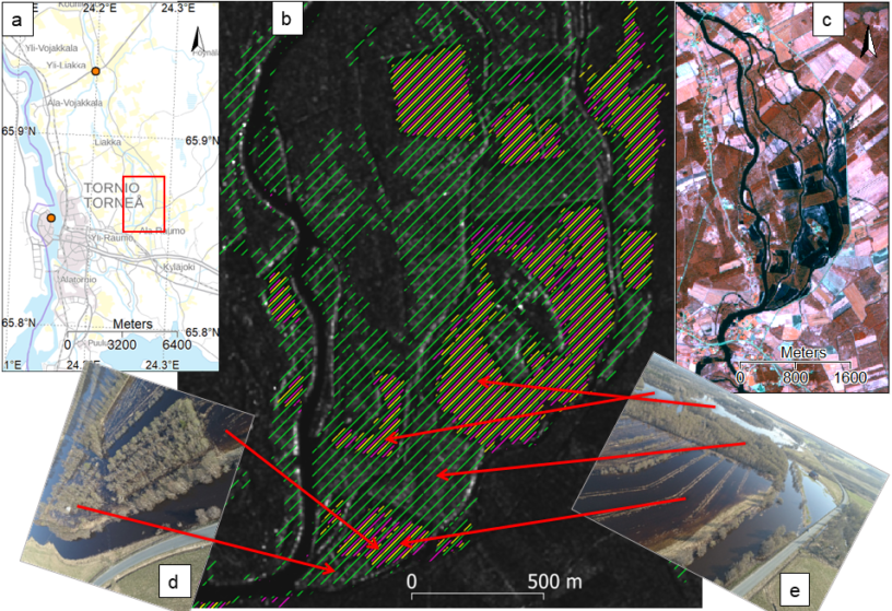
In a recent research, the accuracy of Flood Centre’s Flood Detection Algorithm (FC-FloDA) was assessed, and the flood maps were compared with other available methods and products. The FC-FloDA products were found to be superior to the others in typical Finnish boreal forest environments. The major benefit in the Flood Center’s products was the ability to detect floods in forests, in addition to the detection of floods in open treeless areas. For example, flood maps provided by the Copernicus Emergency Management Service (EMS) showed floods in open areas but did not detect floods under tree canopies.
The superiority of Flood Centre’s product is primarily based on the selection of the optimal satellite sensor and the customization of the algorithm for detecting floods in forests in addition to floods in open areas. Detection of open water surface with remote sensing is relatively easy, while recognition of water surfaces below tree canopies is more complicated, and therefore detecting forest floods requires special tuning of the algorithm.
In the Flood Centre, a synthetic aperture radar (SAR) satellite sensor operating in microwave frequencies is used, because it can see through clouds, and it penetrates tree canopies better than optical sensors. Also, the transmitting and receiving polarization is chosen so that the floods in forests can be better detected. Moreover, datasets providing accurate information about land cover, forest properties and ground elevation, produced by the Finnish Environment Institute and the Finnish National Land Survey are utilized as ancillary data.
More information
Researcher Juval Cohen, Finnish Meteorological Institute, juval.cohen@fmi.fi
Cohen, J., Heinilä, K., Huokuna, M., Metsämäki, S., Heilimo, J., & Sane, M. (2021). Satellite-based flood mapping in the boreal region for improving situational awareness. Journal of Flood Risk Management, e12744.
Scientific article available at: https://doi.org/10.1111/jfr3.12744

Leave a Reply
You must be logged in to post a comment.