
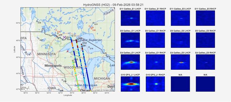
HydroGNSS, ESA’s first Scout mission developed under the FutureEO programme and led by Surrey Satellite Technology Ltd (SSTL), is demonstrating a novel approach to observing key components of the global water cycle. The mission is based on Global Navigation Satellite System Reflectometry (GNSS-R), which uses L-band signals from navigation satellites such as GPS and Galileo. By comparing direct and Earth-reflected signals, HydroGNSS can retrieve valuable information on environmental conditions including soil moisture, inundation, and freeze–thaw state.
The HydroGNSS satellites have been successfully launched and are currently in the commissioning phase, during which their instruments and measurement capabilities are being tested and calibrated in orbit. The mission is expected to significantly improve hydrological monitoring worldwide.
The Finnish Meteorological Institute (FMI) plays an important role in the HydroGNSS mission by developing methods to detect soil freeze–thaw conditions from GNSS-R observations. Freeze–thaw dynamics are a key component of cold-region hydrology and strongly influence water, energy, and carbon exchanges between the land surface and atmosphere. FMI’s work supports the generation of new satellite-based products that enhance monitoring of seasonal transitions in northern regions.
HydroGNSS data and derived products are expected to provide new opportunities for scientific research and operational applications, particularly in high-latitude environments where traditional observations are limited.
More information
Kimmo Rautiainen, Senior Research Scientist, kimmo.rautiainen@fmi.fi
News article on ESA’s web page:
ESA’s HydroGNSS on track to scout for water
News article on Surrey Satellite Technology LTD (SSTL) web page:
HydroGNSS Satellites Proving In-Orbit Capabilities
Youtube video of HydroGNSS Trackset and First Delay Doppler Maps by SSTL:
Leave a Reply
You must be logged in to post a comment.