
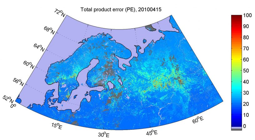
A recent study of the FMI and the Finnish Environment Institute (SYKE) introduced an approach to characterize uncertainty in the mapping of snow extent from optical satellite images. The implementation of the developed method can enhance flood prevention and the optimization of hydro-power production.
A typical bottleneck in the utilization of the satellite-based information is how to define the reliability of the data. In this study the problem was tackled for the first time regarding optical satellite data-based snow cover information.
As a result, a mathematical description of the total error in a satellite product pixel (e.g. 1 km by 1 km) representing snow covered area (in %-units) was developed. The errors in snow products are usually inherited by the different hydrological or meteorological models or model forecasts using the data, so it is highly important to quantify the amount of error.
The basic concept of the developed method lies on the fact that any snow model is not an exact representation of the true situation, but merely an approximation. So, when using only typical values as snow model parameters, there will be systematic error in the results. Then again, an approximate model includes parameter values that are considered as constant but in reality vary spatially or temporally. This causes statistical random error to the results. The statistical error component in a satellite pixel can be quantified through the so called error propagation approach. This information can then combined with the systematic error contribution assessed through a comparison with available reference data sets (e.g. operational ground based observations on snow conditions from snow courses).
The implementation of the developed method will directly benefit the forecasting of river discharges in regions of seasonal snow cover such as Finland, and thus enhance flood prevention and the optimization of hydro-power production.
More information:
Research Scientist Miia Salminen, miia.salminen@fmi.fi
Salminen, M., Pulliainen, J., Metsämäki, S., Ikonen, J., Heinilä, K., and Luojus, K., 2018. Determination of uncertainty characteristics for the satellite data-based estimation of fractional snow cover. Remote Sensing of Environment, 212, 103-113. https://doi.org/10.1016/j.rse.2018.04.038
https://www.sciencedirect.com/science/article/pii/S0034425718301950

Leave a Reply
You must be logged in to post a comment.