
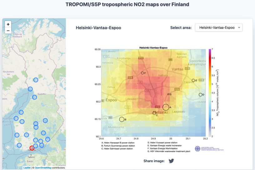
A new online platform developed at the Space and Earth Observation Centre (FMI-SPACE) provides maps of nitrogen dioxide (NO2) concentrations over many Finnish cities (http://sampo.fmi.fi/airpollution/no2/). The largest NO2 concentrations correspond to city centers, major traffic lanes, ports and other stationary sources (power plants or factories).
The average maps are based on the tropospheric NO2 retrievals derived from the Copernicus TROPOspheric Monitoring Instrument (TROPOMI). TROPOMI is the only payload onboard the Copernicus Sentinel-5 Precursor satellite and it has been providing NO2 data since February 2018. Due to their global coverage, satellite data can be used to monitor air pollution all over the world.
NO2 is an air pollutant mainly generated by combustion processes from anthropogenic pollution sources (including transportation, energy production and other industrial activities). Concentrations of short-lived gases like NO2 can be used as proxies of NO2 emissions when averaged in time and space, since averaging removes some of the short-term variability due to changing meteorological conditions.
The service is part of the Health showcase of the EU 2020 e-shape project (Pilot 2.3 EO-based pollution-health risks profiling in the urban environment). TROPOMI NO2 retrievals are developed at the Royal Netherlands Meteorological Institute (KNMI) and distributed via the Sentinel Hub.
Site address: http://sampo.fmi.fi/airpollution/no2/
More information: Responsible investigator Iolanda Ialongo, iolanda.ialongo@fmi.fi, @iolandaialongo

Leave a Reply
You must be logged in to post a comment.